Canterbury Champs
- Map:
- Castle Hill
- Event Type:
- Canterbury Champs
- Planner:
- Peter Cleary
- Controller:
- Jenni Adams
- Co-ordinator:
- Melanie Brigden
Welcome to the 2018 Canterbury Champs regional 2-day orienteering carnival featuring two of our very favourite maps.
On Saturday evening we will have a shared meal, even if you are not staying at the lodge, you are welcome to bring a plate and join in. This is an open event for anyone to enter.
Start lists: The start lists for Saturdays MIDDLE distance can be found here: coc-2018-middle-starttimes-v4.pdf
Assembly area, start and finish: The assembly area is in the grounds beside the STAC lodge. The start is adjacent to the finish area.
Health and Safety: The courses cross the road into the STAC lodge. If driving in after 12:15pm, please drive in very slowly as there could be runners on, or crossing the road. Many courses cross or travel along aside a small stream. It is easy to cross but care should be taken.
Registration: There is no need to go to registration if you have pre-entered, have your own SI card and have paid in full. Otherwise - head to registration.
Costs: We have made these costs comparable to entering an evening rogaine/fun run. We have some event management and planner/controller expenses, etc to cover. We think the event and accommodation are good value for a short summer get-away weekend with excellent navigation in excellent NZ native bush surroundings. This is some of the best challenging South Island terrain available to run in.
- Saturday - Middle distance |Senior: $20 Junior (13-20): $15 Child (12 and under): $5. Maximum family rate $50
- Sunday - Long distance Senior: $25 Junior (13-20): $20 Child (12 and under): $5. Maximum family rate $60
Entry: Sorry entries for this event have now closed and pre-entry was a requirement.
Terrain: The terrain is a mixture of river terraces and landslip moraine. It is mostly covered with native beech, but includes open tussock and rejuvenating manuka, as well as some developed urban terrain. Includes numerous small hills and depressions. The bush is mostly runnable and includes a detailed track network, but has some greener areas.
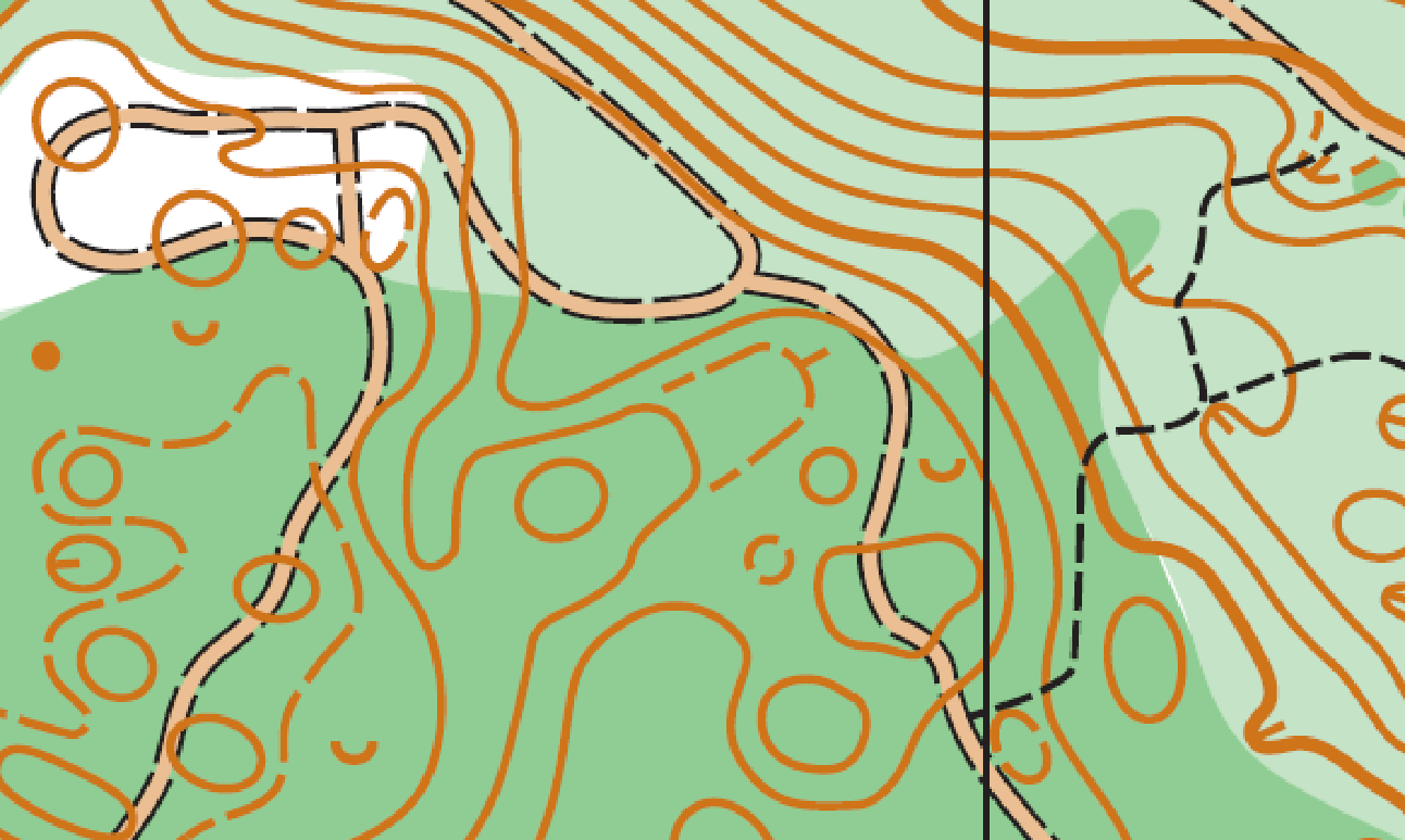
Mapped at: 1:4000 with 2.5m contours. The map is drawn to ISSOM2007.
Note: ISSOM2007 means sprint map specifications. A legend with the sprint map specifications can be accessed here
Although most sprint map specifications are quite similar to non-sprint maps, one notable difference is the way unpaved tracks are drawn on sprint maps. These are illustrated in the map snip below – the light-brown track symbol with dashed lines along the border are unpaved, normal forest walking tracks. These would typically be mapped with a narrow black dashed line on a non-sprint map. The black dashed line on a sprint map is used for smaller tracks, which, in this case at Castle Hill, although smaller, are not markedly different from the tracks mapped with the light-brown track symbol
Courses:
| Course | Length | Climb | |
| 1 | 4.2 km | 150 m | M21E |
| 2 | 3.7 km | 150 m | M20A, M21A, W21E |
| 3 | 3.4 km | 140 m | M18A, M40A, W20A |
| 4 | 2.8 km | 110 m | M16A, M21AS, M50A, W18A, W21A, W40A |
| 5 | 2.5 km | 80 m | M40AS, M60A, W16A, W21AS, W50A |
| 6 | 2km | 50 m | M70A, W40AS, W60A, W70A |
| 7 | 2.5 km | 85 m | M14A, M18B, M21B, W14A, MRec1, WRec1 |
| 8 | 2.3 km | 60 m | M40B, W18B, W21B, W40B, MRec2, WRec2 |
| 9 | 2.2 km | 85 m | M12A, M14B, M21C, W12A, W14B, W21C |
| 10 | 2.1 km | 65 m | M10, M12B, W10, W12B |
Directions: Castle Hill Village is located in the Canterbury high country 100km west of Christchurch and about 33km west from Springfield (great pie stopover) over Porters Pass. take SH73 towards Arthurs Pass to Castle Hill village. Turn off the road towards Castle Hill village, follow the road past the tennis courts on your left, after 300m you will reach a sharp left turn, at this point bear right. After another 200m on the gravel road to your descend a slope to a flat area with a fork in the road, you take the left fork to a gated bridge (which should be open for you). The road after the bridge has a sharp left bend and is quite steep. If you have a four wheel or rear wheel drive you can proceed past the bridge, but use first gear and take it slow. The lodge is 150m past the bridge. Allow at least 1 hour and 15 minutes from Christchurch International Airport to the Castle Hill village and a bit longer for the final gravel section.
Note: There will be no signposting on SH73.
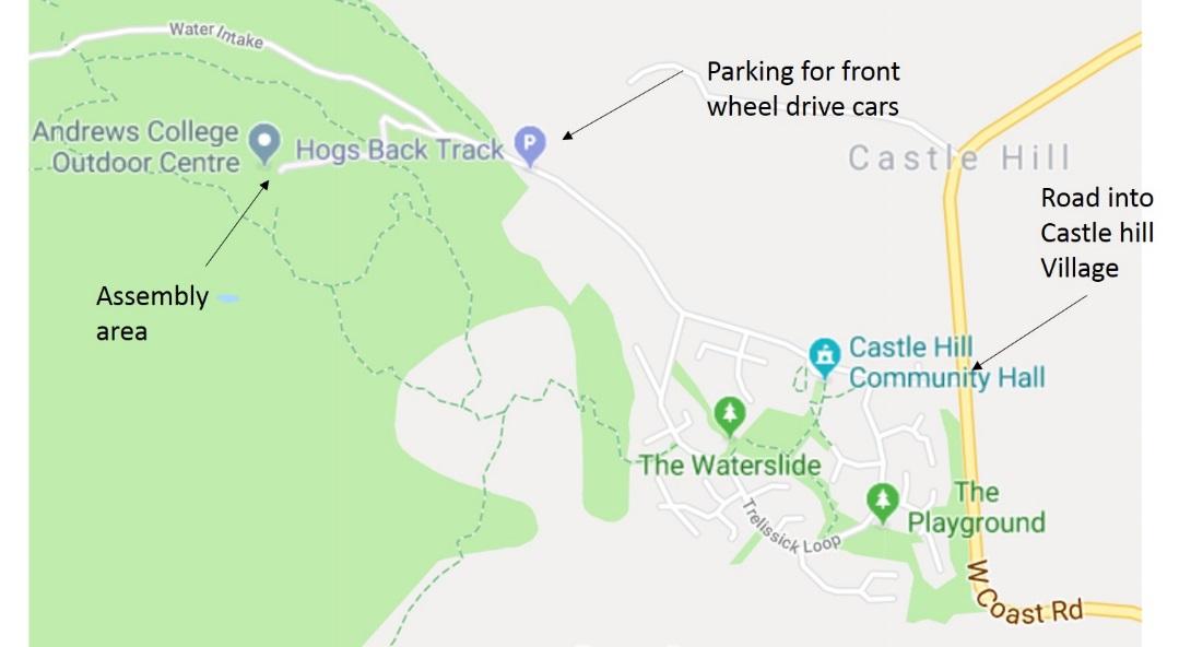
Parking: St Andrews prefer that four wheel/rear wheel only drive vehicles are driven over the access bridge. Front wheel drive vehicles have previously destroyed the surface of the gravel road. There will be orienteering event signposting, but please be aware there will be a short walk to the start at the lodge if your car is a front wheel drive. So bring footwear and clothing suitable for both orienteering and walking in and out. Access to lodge is open for those staying the evening. If we have adequate 4WD vehicles, we could pool transport into 4WD/rear wheel vehicles and drive as many people and as much gear as possible. This could take some time, so please allow before event.
Wasps: Extensive baiting operations have been run but the wasps are still present. Usually wasps should not be an issue in early December – it is generally over the height of summer and early autumn that they pose problems. Please be aware if you are allergic and come prepared.
4pm-ish onwards (or at a similar time - TBA)
Control collection - many legs make this go faster. We appreciate help to either collect and sort stakes and control boxes so we can get onto shared meal & socialising.
5.30pm onwards
Shared pot luck meal - all welcome. Time for a bit of socialising and a shared meal - please something savoury and a desserty option. There will most likely be a sausage sizzle fundraiser for young orienteers.
Evening info session:
Special General Meeting -To suggest we change the current constitution. The committee propose to have a annual audit review of the PAPO accounts, changing from the current Full Audit.
- A brief discussion and look at next year’s PAPO calendar
- Sharing info from some school students and families who competed in Australia
- Perhaps a presentation from anyone who attended NZ Rogaine Champs - if anyone willing
- We could talk about Xmas event
- It’s a great opportunity for you to give us any feedback and your ideas on how to make PAPO events even better.
- Anything else that comes up
Accommodation info:
Dorm beds available: The lodge sleeps 40 = 4 x 10 dorm room beds at $35 each. Beds are all bunk beds with no linen or pillows supplied, so BYO linen, kitchen teatowels and towels etc. If you are interested in booking a bed, please email us and provide name and phone contact for people planning to stay, thanks.
- Kitchen: The kitchen is open to the lounge room, and has a large gas stove, oven trays and lots of pots and pans to cater for up to 50 people. All the plates and cutlery are provided along with the utensils needed to produce meals.
- Camping: Camping around the lodge is available when the lodge is full and we need to advise on how many are camping. There is a cost of $15.00 per person. The erection of marquees outside the lodge is not allowed, and no outside open fires.
- Cleaning: We have not charged you for cleaning charges in your accommodation fee so we must clean up after ourselves. Food waste must also be removed. If the lodge is not found in the same state in which it was when we arrived we will be charged extra. Please allow time to help clean on Sunday morning before you go to the day’s orienteering event.